

제품상세보기
Nautical Publications

The Solent and adjacent waters
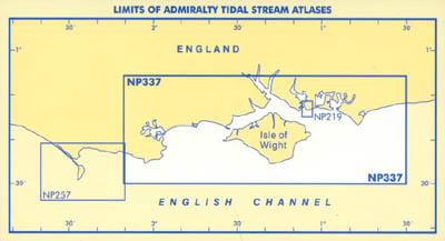
This Edition of NP337 has been reschemed to a larger scale to depict Tidal Stream information for the western and eastern approaches separately. There is an overlap covering the area between Cowes and Stansore Point and the western limit abuts the eastern limit of NP257, Approaches to Portland.
This atlas contains charts showing tidal streams at hourly intervals commencing 6 hours before HW Portsmouth and ending 6 hours after HW Portsmouth. The times of HW Portsmouth and other details of the prediction for this port are given in NP201, Admiralty Tide Tables Vol.1, which is published annually. NP201 also gives tidal predictions for a number of ports and tidal stations in the area covered by this atlas.
On the charts the directions of the tidal streams are shown by arrows which are graded in weight and, where possible, in length to indicate the approximate rate of the tidal stream. thus -> indicates a weak stream and --> indicates a strong stream.
The figures against the arrows give the mean neap and spring rates in tenths of a knot, thus: 19,34 indicates a mean neap rate of 1.9 knots and a mean spring rate of 3.4 knots. The comma indicates the approximate position at which the observations were obtained.
